W H E N Y O U H A V E G U E S T S
S A L T L A K E C I T Y
Sugar House
A week with us
The Wasatch · the city · the red-rock country · the great salt lake
LIVE FIELD EDITION · SEPTEMBER 2026
This is the Live Field Edition. The week is being tested in Salt Lake City from 26 September to 3 October 2026 and will be updated afterward with what worked and what changed.
Live Field Edition · 18 pages
Field Packet · 37 pages
LIVE FIELD EDITION · 1
                   T H E   H O M E   I N D E X

           W H E N Y O U H A V E G U E S T S

SALT LAKE CITY
                     Sugar House

                        A week with us

The Wasatch · the city · the red-rock country · the great salt lake

             LIVE FIELD EDITION · SEPTEMBER 2026
LIVE FIELD EDITION · 2
You are staying with us in Sugar House for a week. This is the week we
would give you.
It is written for the first weeks of autumn, when the aspens turn gold in the high
country, the desert has cooled enough to walk in, and the evenings are still long enough
to be outside.
Seven days is room for four landscapes. A mountain range that begins at the end of the
street. A city laid out on a grid and an idea. The red-rock country four hours south. The
great salt lake to the west. Between them sits a day at the house, because the day after the
longest one should be good too.
You will see a great deal of Utah this week, and some of it from the car. That is not a
compromise here. In Utah, the road can be part of what you came to see.
Most lunches happen at our table. The picnic comes out when the place deserves it.
Dinner is at home, nearly every night.

THE WEEK

SATURDAY            Arrival                    Shop together, settle in, one view
SUNDAY              The Wasatch                Over the crest and around Timpanogos
MONDAY              Salt Lake City             The ground, the founding, the view
TUESDAY             The Big Utah Day           Goblin Valley, Capitol Reef, the road between
WEDNESDAY           The Day After              Home, and Ensign Peak at sunset
THURSDAY            The West                   Antelope Island and the lake
FRIDAY              The Last Open Day          Whatever the week has not yet given you

LIVE FIELD EDITION · SEPTEMBER 2026                                                             2
LIVE FIELD EDITION · 3
PLATE 1
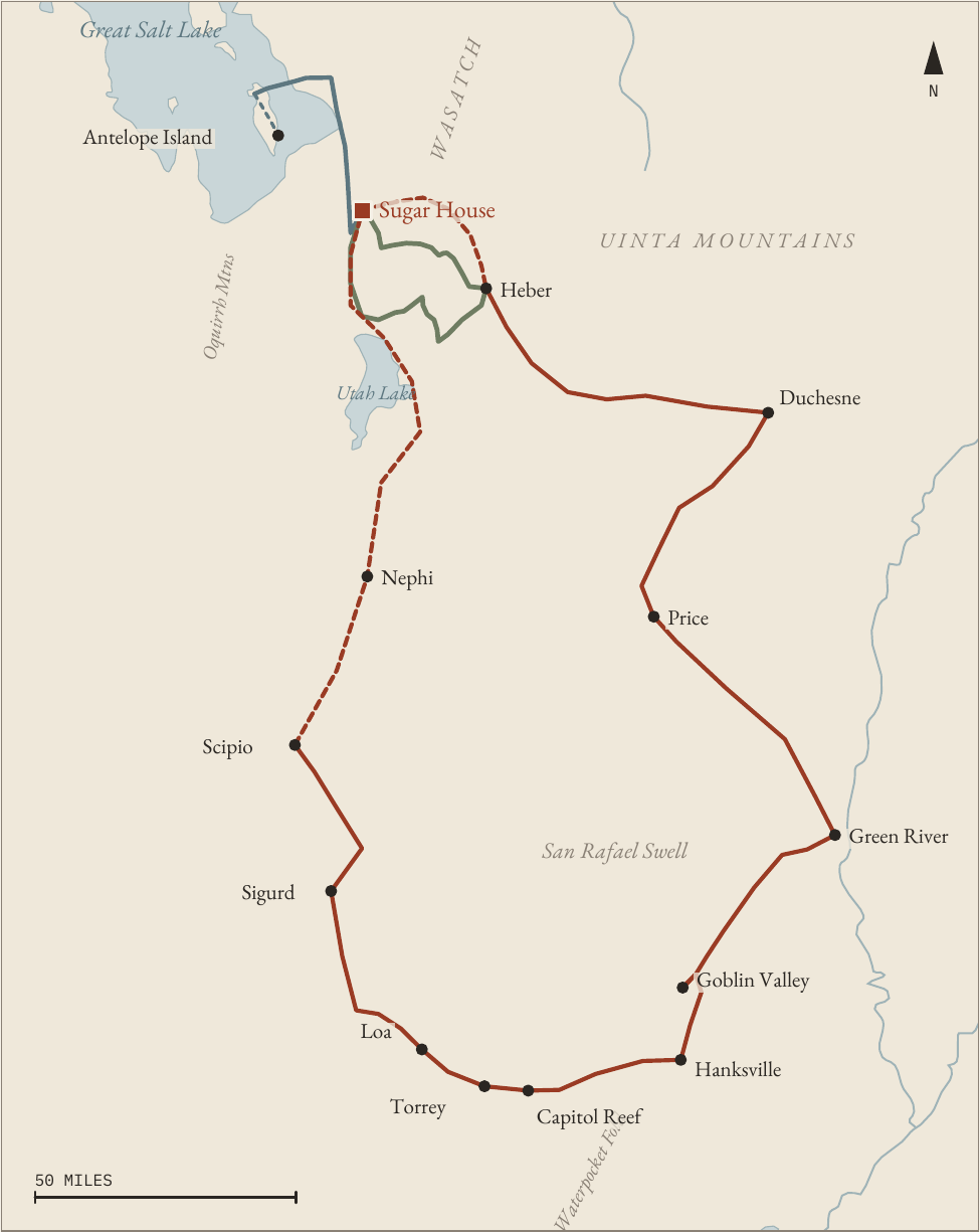
The week from Sugar House
LIVE FIELD EDITION · 4
S A L T   L A K E    C I T Y

In Five Minutes, from Sugar House
Learn five things and the week makes sense.

The wall to the east. The Wasatch stands along the whole eastern edge of the city, close
enough to read the weather off it from the kitchen window. It is not a range in the
distance. It is the end of the street, and twenty minutes of driving puts you inside it.
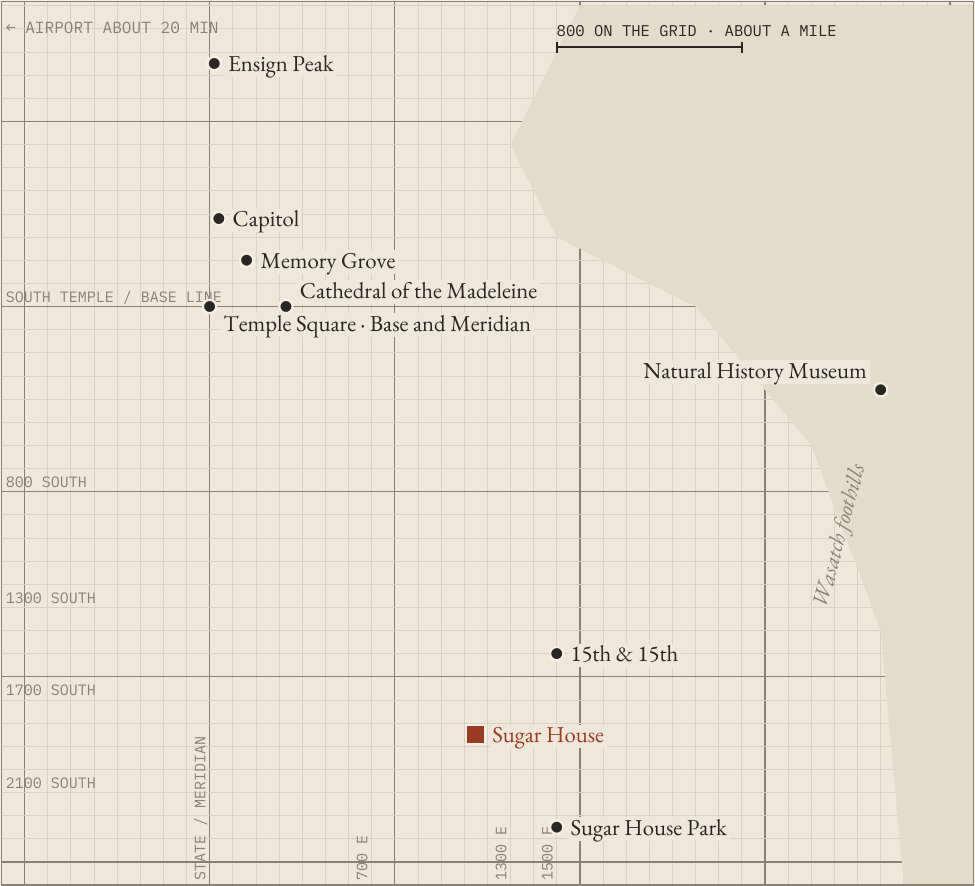
The grid. The city was laid out from Temple Square in 1847, with its streets set to the
compass points and made a hundred and thirty-two feet wide. An address here is a pair
of coordinates. 1300 South is thirteen blocks south of the Temple; 1500 East is fifteen
blocks east. The blocks are long: a change of about eight hundred in the numbers is
roughly a mile, so three blocks is most of half a mile, not a stroll.
The valley to the west. West of the grid the ground opens for thirty miles to the Oquirrh
Mountains, with the Great Salt Lake beyond. The evenings end in an enormous amount
of sky.
Sugar House. Where you wake up. Older houses, big trees and a quiet grid in the
south-east of the city, about four miles from downtown, with Sugar House Park a short
walk away and the canyons a short drive.
The car. This is a week with a car. The mountains and the desert are the reason for it. We
drive, and the driving is part of the week rather than the cost of it.

And the one that matters most this week: in Utah, the road can be part
of what you came to see.

LIVE FIELD EDITION · SEPTEMBER 2026                                                        4
LIVE FIELD EDITION · 5
S A T U R D A Y

Arrival
Shop together, settle in, one view if there is light

  THE DAY

  afternoon       Airport, then Costco and          18:45           This Is The Place
                  Whole Foods                                       Monument
                  Wine from the state store         19:17           Sunset over the valley
  early evening The house: unpack, settle in        about 20:00     Dinner at home

Salt Lake City's airport is about twenty minutes west of the house. We meet you there.
We do not go straight home. On the way we stop at Costco and then at Whole Foods, and
we shop for the week together. You choose what the house should hold while you are
here: breakfast, the fruit you like, the snacks you actually eat, what you want for lunch,
what you would like to drink. Most of this week's lunches happen at the kitchen table and
most of its dinners too, so this is where the week is stocked.
Wine in Utah is sold only in state liquor stores, not in supermarkets, and those stores are
closed on Sundays. The bottles for the week are bought today, on the way home.
Then the house: unpack, put the week away, sit down.
If the flight is kind and the shopping quick, there is light left for one view before dinner.
At a quarter to seven, drive about ten minutes up to the This Is The Place Monument at
the mouth of Emigration Canyon, near where the first Mormon pioneer company looked
out over the Salt Lake Valley in 1847. Walk across the plaza and face west. The sun goes
down behind the Oquirrhs a little after seven, over the whole valley you will spend the
week in.
If the evening has gone to bags and groceries, walk to Sugar House Park instead, a few
minutes away, and look east: for about ten minutes after sunset the mountain wall at the
end of the streets turns pink, then grey. The house being ready matters more than the first
view.
Dinner at home.

WORTH KNOWING
Salt Lake City sits at about 4,300 feet and the air is dry. Drink more water than you think you need
for the first two days, and expect the sun to be stronger than the temperature suggests.

LIVE FIELD EDITION · SEPTEMBER 2026                                                                5
LIVE FIELD EDITION · 6
S U N D A Y

The Wasatch
One canyon up, over the crest, and home around the great peak

  THE DAY

  08:00           Leave, picnic in the car     about 11:30   Sundance
  about 08:45     Big Cottonwood Canyon,       about 12:15   Picnic on the Alpine Loop
                  Silver Lake                  about 14:30   Home
  about 10:15     Guardsman Pass
  about 11:00     Midway and Heber

The mountains at the end of the street are a range, not a wall, and a single day shows you
both its sides.
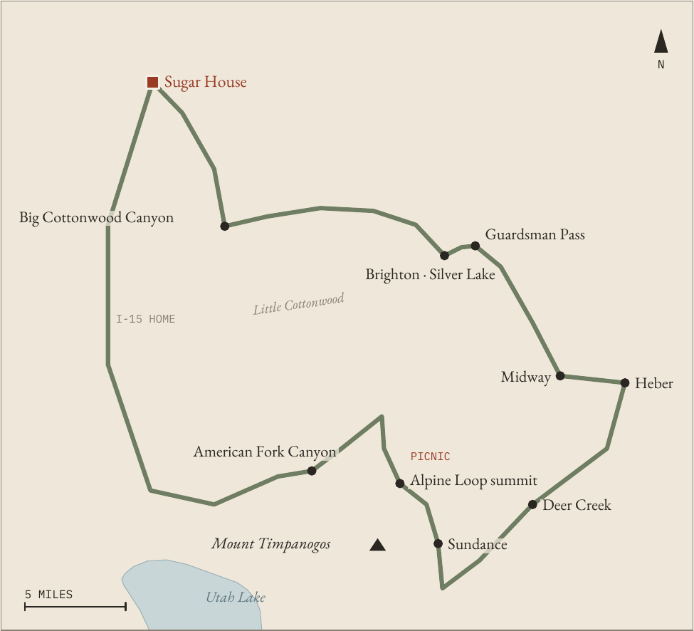
Leave at eight with a picnic in the car. Big Cottonwood Canyon starts twenty-five
minutes from the house and climbs between granite walls to Brighton at its head, where
Silver Lake sits in a meadow ringed by peaks. Walk around it. The path is flat and takes
about three quarters of an hour.
Near the lake, a narrow paved road turns off and climbs to Guardsman Pass, close to
9,700 feet. From the overlook you see both sides of the range at once: the canyons falling
back toward the city, and ahead of you the Heber Valley, green and wide, with farms in
it. In late September the aspens on these slopes go gold.
Drop down through Midway to Heber, then follow Provo Canyon past the Deer Creek
reservoir to Sundance, set in the trees under the east face of Mount Timpanogos. Walk
the grounds for half an hour.
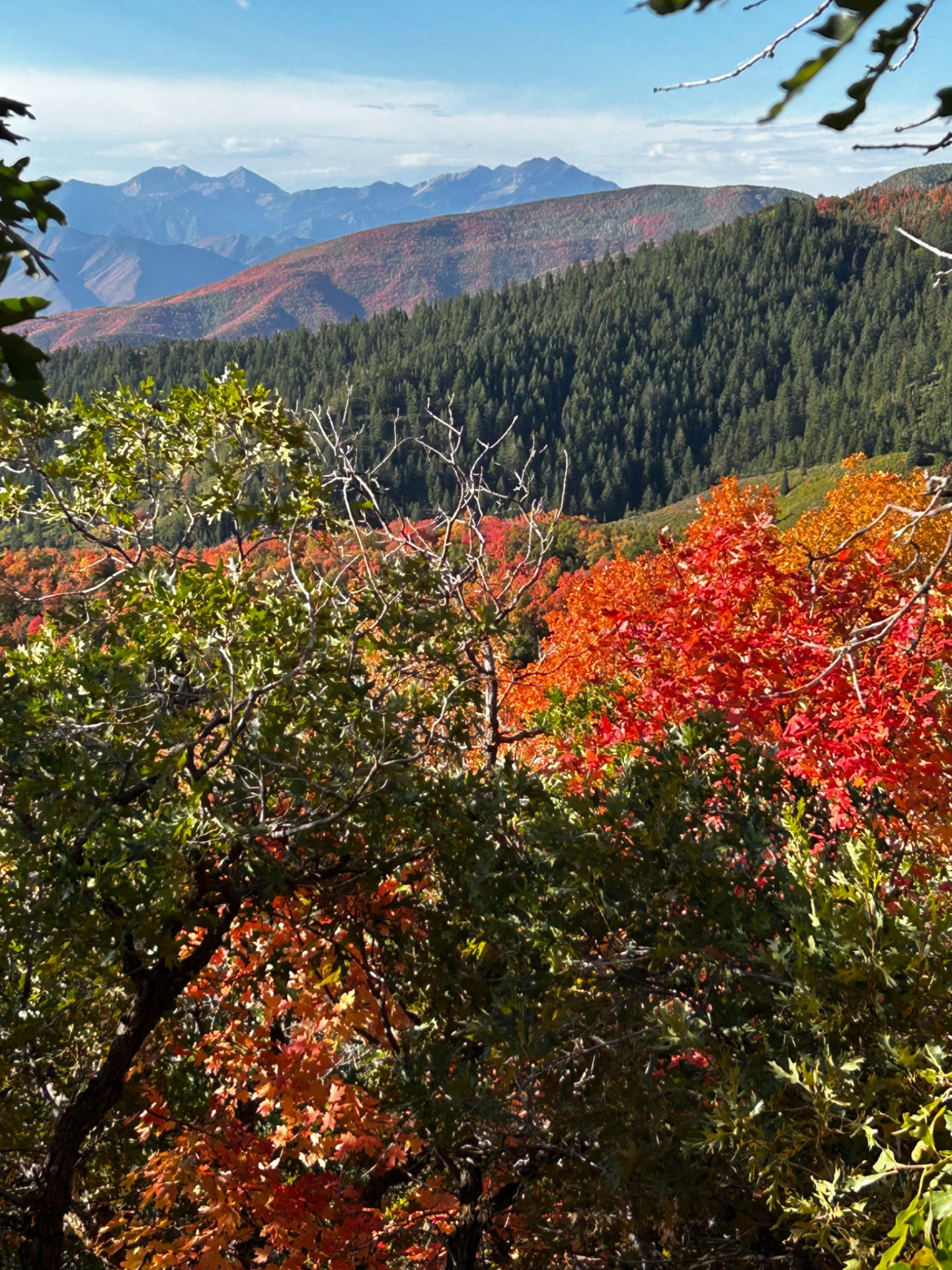
From Sundance the Alpine Loop climbs over the shoulder of Timpanogos, about twenty
paved miles to roughly 8,000 feet and down American Fork Canyon. This is the colour
of the day: aspen gold on the high slopes, and red maples lower down as October arrives.
Stop at a pullout under the mountain for the picnic.
Out through American Fork Canyon to the interstate, and home by mid-afternoon. The
rest of the day belongs to the house.

LIVE FIELD EDITION · SEPTEMBER 2026                                                        6
LIVE FIELD EDITION · 7
PLATE 2
The Wasatch day
LIVE FIELD EDITION · 8
M O N D A Y

Salt Lake City
The ground, the founding, and the city from above

  THE DAY

  09:00           Red Butte Garden              about 15:15    Capitol, Memory Grove
  12:00           Tabernacle organ recital,                    Cathedral of the Madeleine
                  Temple Square                 about 18:00    Home, early dinner
  about 13:30     Lunch at home

Salt Lake City is a city founded on an idea, sitting in a landscape that explains itself. The
morning places the city in its landscape, the middle of the day explains its founding, and
the afternoon shows the city from above and ends somewhere quiet.
Start at nine at Red Butte Garden, on the foothills above the university. Walk the main
loop through the themed gardens, then take the trail up into the Garden's natural area,
where the whole valley, the mountain ranges around it and, on a clear morning, the
Great Salt Lake lie below you.
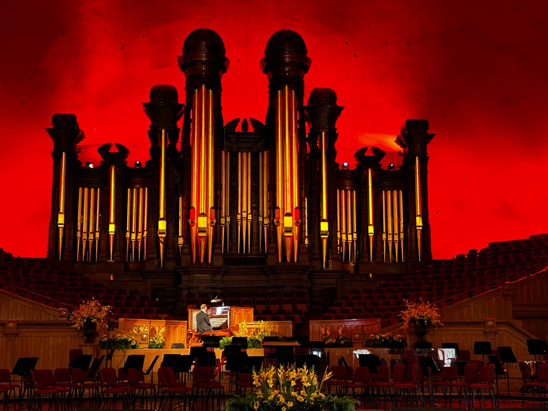
Then downtown to Temple Square before noon. At twelve the Tabernacle organ plays a
free half-hour recital under a roof that spans a hundred and fifty feet without a pillar; the
acoustics are the building's own story. Afterwards, walk the square and find the Base and
Meridian marker at its south-east corner, the point from which every address in the valley
is counted.
Home for lunch, fifteen minutes away, and a rest.
Go back out in the middle of the afternoon to the Capitol, on the rise north of
downtown, and look back at the grid you have been reading all day, with the Oquirrhs
across the valley behind it. Walk down into Memory Grove, where City Creek runs
through a small canyon at the edge of downtown. End at the Cathedral of the Madeleine
on South Temple: a large, dark, richly decorated interior, free and quiet, and a different
Salt Lake City from the one around the Temple.
Home by six, and an early dinner. Tomorrow starts early.

LIVE FIELD EDITION · SEPTEMBER 2026                                                         8
LIVE FIELD EDITION · 9
PLATE 3
The city on its grid
LIVE FIELD EDITION · 10
T U E S D A Y

The Big Utah Day
Goblin Valley, Capitol Reef, and the road between them

  THE DAY

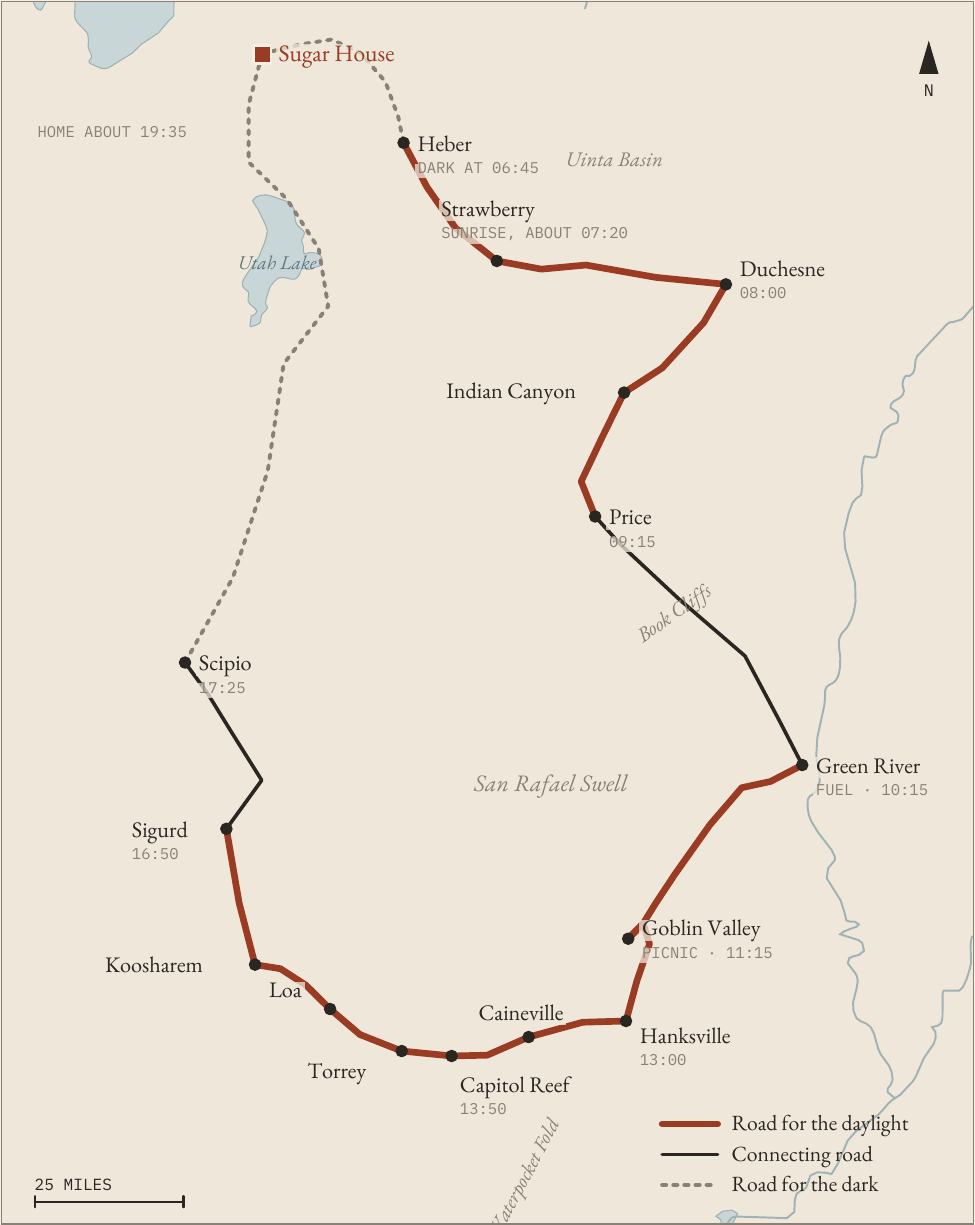
  06:00           Leave in the dark              11:15          Goblin Valley, picnic
  about 07:20     Sunrise over Strawberry        13:50          Capitol Reef, Fruita
  08:00           Duchesne                       15:35          The high valleys
  09:15           Price, by Indian Canyon        17:25          Interstate home
  10:15           Green River, fuel              about 19:35    Dinner at home

This is the long day, and the car is not the price of it. Between leaving the house in the
dark and sitting down to dinner, the land changes character again and again: high
sagebrush country, a forested pass, coal towns under grey cliffs, a desert of standing
stone, a green river canyon with orchards in it, and high valleys of hay and cattle going
gold in the late light.

 Save daylight for the road that earns it. Spend darkness on
                    the road that doesn't.

We leave at six, while the first stretch of interstate and the Heber Valley are still dark; you
will see both again this week. The sun comes up over the Strawberry high country, and
from there until evening nearly every mile is worth looking at.
The high country. Down into the Uinta Basin at Duchesne, then south through Indian
Canyon, up through forest and over the top, and down to the old coal towns of Helper
and Price.
Into the desert. Past Price the road runs under the Book Cliffs to Green River, where we
fill the tank once for the whole day. South on Highway 24, the San Rafael Reef rises on
the right, a long wall of tilted rock, and a paved side road leads to Goblin Valley.
Goblin Valley. Thousands of stone figures, carved by weather from sandstone laid down
about 170 million years ago, stand crowded together in three shallow valleys. There are
no trails among them and none are needed: walk down from the observation point into

LIVE FIELD EDITION · SEPTEMBER 2026                                                          10
LIVE FIELD EDITION · 11
the First Valley and wander a loop of about a mile, 35 to 40 minutes. Short on time, go
only as far as the nearest goblins and back, 10 to 15 minutes. Lunch is a picnic here, the
one meal of the day away from home, and the place is the reason.
West along the Fremont. Through Hanksville the road turns west. Past Caineville the
land goes grey and bare, with Factory Butte standing off to the north like something
from another planet. Then the Fremont River cuts into the Waterpocket Fold and
everything turns red and green at once.
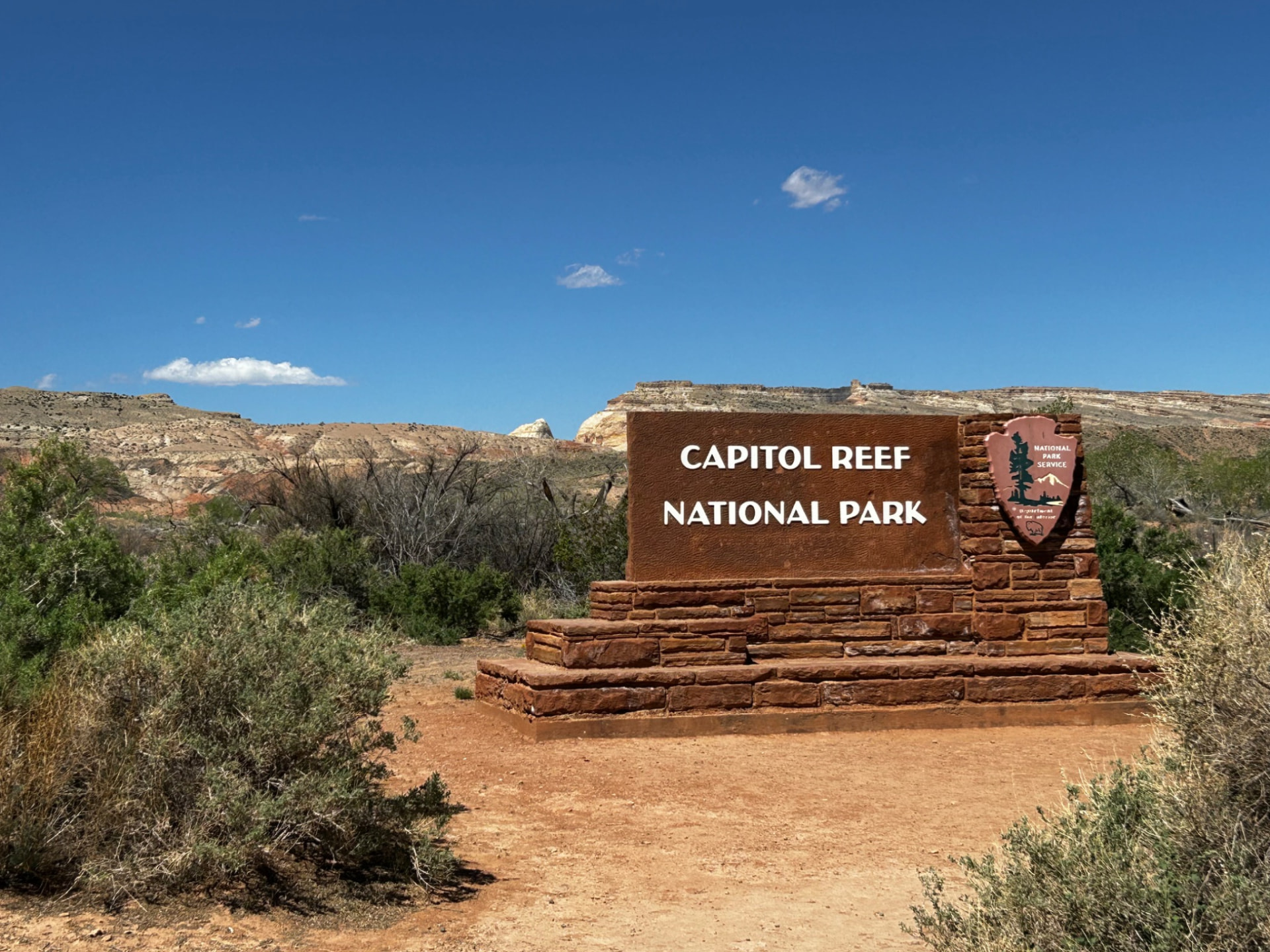
Capitol Reef. Fruita is the old pioneer settlement in the canyon, with its orchards still
growing between the cliffs. Look for the petroglyphs on the canyon wall, buy a pie at the
Gifford House before it closes, and on the way out walk to Sunset Point, 0.8 mile there
and back, 25 to 30 minutes, for the whole Waterpocket Fold from above. If time is short,
the Goosenecks overlook from the same parking takes 5 to 10 minutes. If the dirt spur is
wet or the lot is full, Panorama Point, just off the highway, has the view without the
walk. In the afternoon the cliffs take the light.
The high valleys. West of Torrey the road climbs into ranch country, through Loa and
Koosharem, and comes down to the Sevier Valley in full daylight.
Home. The last two hours are interstate. The sun goes down somewhere near the end of
them, and by then there is nothing left to lose to the dark. Dinner is at home, a little after
half past seven.

WORTH KNOWING
About 560 miles and 9½ hours of driving; home around 19:30.
One fuel stop, at Green River. There is no fuel between Hanksville and Torrey.
Pack the picnic and more water than seems necessary.
Goblin Valley State Park charges a day-use fee per vehicle; restrooms are at the observation point.
The Gifford House at Capitol Reef closes at 16:30.
If the day runs late, it is the stops that shorten, not the road through the high valleys.

LIVE FIELD EDITION · SEPTEMBER 2026                                                                   11
LIVE FIELD EDITION · 12
PLATE 4
The Big Utah Day
LIVE FIELD EDITION · 13
W E D N E S D A Y

The Day After
Home, an easy day, and Ensign Peak at sunset

  THE DAY

  morning         Slow; 15th and 15th if you     18:00          Ensign Peak
                  like                           about 19:10    Sunset from the top
  about 13:00     Lunch at home                  about 20:15    Dinner at home
  afternoon       Nothing

Nobody sets an alarm.
The morning is slow. If you want to walk, go to the corner of 1500 South and 1500 East,
which everyone calls 15th and 15th, for coffee at the bakery and a look around the Italian
market next door; we will need a few things for tonight. Lunch at home.
The afternoon has nothing in it on purpose.
At six, drive up behind the Capitol to the foot of Ensign Peak. The path to the top is
about a mile there and back, steep and short. Within days of the first pioneer company
reaching the valley in July 1847, a small group climbed this hill to look over the ground
where they meant to build a city. From the top you see what they saw and what they
made of it: the grid you have been reading all week, the Capitol below, the Oquirrhs
across the valley and, on a clear evening, the lake. The sun sets at about ten past seven.
Bring a light for the walk down.
Then home, and a long dinner. Tonight it is the main event.

WORTH KNOWING
Ensign Peak is short but steep; wear shoes with grip.
If the evening is wet, the Natural History Museum stays open until 21:00 on Wednesdays.

LIVE FIELD EDITION · SEPTEMBER 2026                                                          13
LIVE FIELD EDITION · 14
T H U R S D A Y

The West
Antelope Island and a sunset over the lake

  THE DAY

  12:30           Lunch at home                       about 16:15     North slowly, watching for
  13:45           Leave                                               bison
  about 14:30     Causeway; information at the
                                                      about 18:30     Buffalo Point walk
                  Marina                              about 19:05     Sunset over the lake
  about 15:05     Fielding Garr Ranch                 about 20:35     Dinner at home

The other half of the geography. This valley was once the bed of an enormous lake. This
afternoon you go and stand in what is left of it.
Lunch at home, then north on the interstate and west through Syracuse to a seven-mile
causeway laid straight across the Great Salt Lake. At the far end is Antelope Island, the
largest island in the lake, open range where some six hundred bison live wild alongside
pronghorn, mule deer and bighorn sheep.
The visitor centre is closed for construction; temporary information is at the Marina, on
the right as you reach the island. Take the road down the east side, about eleven miles, to
the Fielding Garr Ranch, a historic pioneer ranch, then come back north slowly, watching
for bison.
Toward half past six, walk up Buffalo Point, a short climb near the north end, and watch
the sun go down over the lake. The lake is shallow and often very still, and the light goes on
for a long time after the sun is down. The drive home is on the interstate, in the dark, which
costs nothing.
A late dinner at home.
INSTEAD OF THE SUNSET

On a Thursday evening the Tabernacle Choir usually rehearses in the Tabernacle, free and open to the
public, from half past seven. If that matters more to you than the sunset, leave the island by five, eat
early at home, and go downtown.
WORTH KNOWING
Day-use fee per vehicle at the causeway.
The visitor centre is closed for construction; temporary information is at the Marina. The ranch is open
until 17:00.
The lake is low. In places the shoreline is a long walk from the road, and the exposed lakebed can smell
of brine.
The bison are wild. Keep your distance, and stay in the car if they are close to the road.

LIVE FIELD EDITION · SEPTEMBER 2026                                                                    14
LIVE FIELD EDITION · 15
F R I D A Y

The Last Open Day
Kept free for whatever the week has not yet given you

By Friday you will know what is missing. This day stays open for it, with lunch at home
and the last dinner of the week at the table.
If the weather took a day, take it back. The Wasatch and the West both move easily to
Friday.
If you have not yet walked in the high mountains, go to Little Cottonwood Canyon, the
steeper granite canyon beside Big Cottonwood. At its head is Alta and the high meadows
of Albion Basin, where a path of just under a mile each way climbs to Cecret Lake under
a ring of peaks. When the Snowbird tram is running, it lifts you 2,900 vertical feet in
about ten minutes to Hidden Peak, at 11,000 feet, with the Wasatch laid out around
you. Back for lunch.
If you would rather see a mountain town, Park City is forty minutes away over Parleys: a
silver-mining town from the nineteenth century, now a ski town, best walked slowly up
its old Main Street. Back for lunch.
Whatever Friday becomes, the evening is at home.

WORTH KNOWING
The Snowbird tram and the road to Albion Basin are seasonal; confirm before going.

S A T U R D A Y

The Last Morning
If the flight is in the afternoon, the Downtown Farmers Market at Pioneer Park runs on
Saturday mornings from eight until two, through late October. Walk it, bring something
home, and have lunch at the house before the airport.
On the first weekend of October the city hosts the twice-yearly General Conference of
the Church of Jesus Christ of Latter-day Saints, and downtown fills up. Allow extra
time.

LIVE FIELD EDITION · SEPTEMBER 2026                                                          15
LIVE FIELD EDITION · 16
B E F O R E    Y O U    C O M E

Small Things Worth Knowing
Altitude and sun. The valley is at about 4,300 feet and the passes you cross are twice that.
The air is dry and the sun is strong. Drink water, wear a hat, and bring a layer to the
mountains even on a warm day.
Wine. Only state liquor stores sell wine and spirits, and they are closed on Sundays. Buy
on Saturday.
Sundays. No wine can be bought, and the mountain roads are at their busiest. Otherwise
the city runs much as usual.
Distances. Eight hundred on the address grid is about a mile. Three blocks is most of half
a mile.
Mountain roads. Canyon roads are narrow in places and parking is allowed only where it
is signed. On busy days police can restrict traffic going up. Guardsman Pass and the
Alpine Loop close for the winter with the first heavy snow.
The desert. Fill up where you can. Services are far apart south of Green River, and phone
coverage is patchy.
Evenings. In late September the sun sets a little after seven. Days are warm in the valley;
mornings and the high country are cool.

CONFIRM BEFORE YOU GO
Tabernacle organ recital: noon, Monday to Saturday; Sunday at 14:00.
Natural History Museum of Utah: 10:00 to 17:00; Wednesdays to 21:00.
Gifford House, Capitol Reef: closes 16:30.
Goblin Valley and Antelope Island: day-use fee per vehicle.
Antelope Island: visitor centre closed for construction, temporary information at the Marina;
Fielding Garr Ranch to 17:00.
Guardsman Pass, the Alpine Loop, Albion Basin and the Snowbird tram: seasonal.
Road conditions on Indian Canyon and Highway 24: UDOT Traffic, the night before.
Costco on a Saturday: closes at 19:00.

LIVE FIELD EDITION · SEPTEMBER 2026                                                             16
LIVE FIELD EDITION · 17
T H E    S H O R T     L I S T

If You Do Only Five Things
1   Stand at the Guardsman Pass overlook and see both sides of the Wasatch at
     once.

2   Hear the Tabernacle organ at noon.

3   Walk down among the goblins, with your lunch.

4   Drive the Fremont River into Capitol Reef in the afternoon light, and eat a pie
     at the Gifford House.

5   Watch the sun go down over the Great Salt Lake from Antelope Island, with
     bison somewhere behind you.

And then, on the evening after the longest day, climb Ensign Peak and look at the whole
valley, the grid, the mountains and the lake, and come home to dinner.
That one isn't on the list. It is what staying with friends is like, and it is the reason the
invitation was worth making.

There is more than a week can hold: another canyon, the salt flats in the far west, a second national park,
the winter version of all of it. That is for the next visit.

LIVE FIELD EDITION · SEPTEMBER 2026                                                                           17
LIVE FIELD EDITION · 18
                            The Home Index · When You Have Guests
                                 Salt Lake City · Sugar House

   Live Field Edition. Research current through 25 September 2026. Field week 26 September to 3
                                          October 2026.
  Maps drawn schematically from town and junction positions, with water from Natural Earth.

                           Set in EB Garamond, with IBM Plex Mono.
                                      Ludovicus Aurelius

                                      Hoc est opus. Et satis est.

LIVE FIELD EDITION · SEPTEMBER 2026                                                        18
Hoc est opus. Et satis est.