My Paris Walks
Walks of Paris
100 Churches
Ludovicus Aurelius
One Hundred Churches
Walk through Paris without rushing to its monuments. Enter the churches you find along the way. Some stand on famous squares; others occupy ordinary streets. Their doors open onto different centuries, but each gives you a place to stop, look, and pay attention. This book records a hundred such churches, entered between October 2018 and October 2026.
Together they span more than a thousand years of building. The bell tower of Saint-Germain-des-Prés was begun in 990, and Saint-Julien-le-Pauvre in the twelfth century. Saint-Étienne-du-Mont still keeps its rood screen, a sixteenth-century gallery of carved stone that crosses the church between the nave and the choir. Pierre Mignard painted the dome of the Val-de-Grâce in the 1660s, and Saint-Marcel, on the boulevard de l’Hôpital, was built in the 1960s. Eighty-four of the hundred stand within the city, in every one of its twenty arrondissements, the city’s administrative districts; sixteen stand beyond it, from Neuilly-sur-Seine and Courbevoie to Vincennes, Villejuif and Versailles. Every one was reached on foot, by métro or by RER, the regional train network.
The chapters follow neighborhoods rather than the calendar, so churches a short walk apart sit together, as they do on the ground. Take them in any order. The record shows when each church was visited, not the streets walked between them; the route is yours to choose.
The record contains 232 visits catalogued so far, not every visit made. Each portrait lists their dates. Forty-three churches have one recorded visit; fifty-seven have more than one. Saint-Sulpice has eleven, from October 2018 to October 2026, more than any other church in the book.
By name, place or catalogue number. French names are the names used throughout.
The thirteen sections
Part One · Within Paris
Part Two · Beyond Paris
Where the churches stand
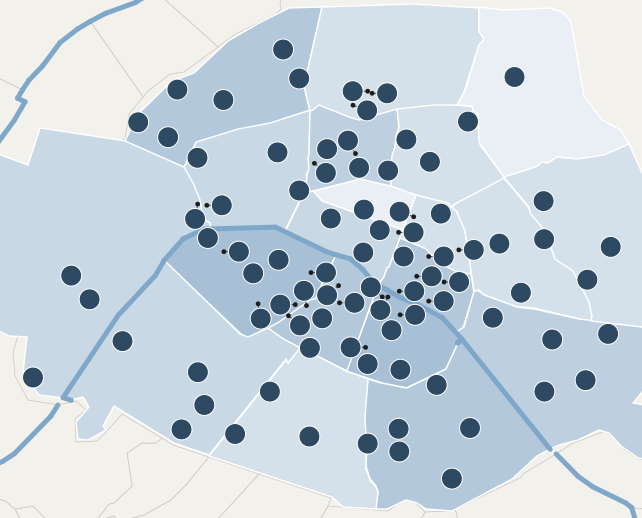 1234567891011121314151617181920212223242526272829303132333435363738394041424345464748495052545556575859606163646566676869707174757681828384858689939496979899100
Numbers are catalogue numbers; a short line joins a number to its church where space is tight. Shading shows how many churches each arrondissement holds, from one to seven; the blue line is the Seine.
Beyond Paris
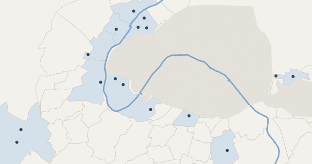 44 Saint-Cyr-Sainte-Julitte51 Saint-Jacques-le-Majeur53 Saint-Étienne62 Saint-Pierre78 Saint-Jean-Baptiste80 Saint-Jacques79 Saint-Pierre-Saint-Paul90 Sainte-Mathilde92 Notre-Dame-de-la-Paix91 Saint-Clodoald87 Basilique Notre-Dame-de-Boulogne95 Sainte-Cécile72 Cathédrale Saint-Louis73 Notre-Dame77 Saint-Louis88 Notre-Dame
Positions are published coordinates; boundaries are simplified. The maps show where the churches stand, not the routes walked between them: a shared visit date does not establish a route, a distance or a duration.
Drawn for this book. Church positions are from published coordinates. Commune boundaries are from the france-geojson collection compiled by Grégoire David, and the arrondissements from an open dataset of their boundaries. In the center of Paris the Seine is drawn from the positions and lengths of its bridges; elsewhere it follows the boundaries that run down the river. Outlines are simplified.
Also in the book
Hoc est opus. Et satis est.